Dynamic monitoring and analysis of number of fishing vessel voyages in Hainan Province based on Beidou position data
-
摘要: 中国近海基于北斗卫星导航系统的渔船监控系统(vessel monitoring system,VMS),在渔船管理和应急救援中发挥了重要作用,同时北斗船位数据还包含位置、时间、航速、航行等信息,可进一步用于渔船航次信息挖掘与分析。文章首先把海陆边界划分成多个0.1°×0.1°的港口格网,然后根据格网与渔船轨迹相交关系,提取海南省2016年的全部航次。海南省渔船以小型为主,航次时间1~5 d占全部航次数的71.8%,各作业类型航次时间平均都在5 d左右;受休渔期、节假日、台风等天气影响,航次频数各月变化有3个峰值和3个谷值;儋州、三亚、文昌3个海南省返回港的航次占航次总数的62.9%,海南省出港非海南省返港的航次主要集中在北海市、阳江市、惠州市等港口。文章基于北斗船位数据的航次提取方法具有普适性,可以直接应用到安装有北斗终端的近海其他省市的渔船。Abstract: China's offshore fishing vessel monitoring system which is based on the Beidou satellite navigation system (contains position, time, speed, navigation and other information) plays an important role in the management and rescue of fishing vessels. In this paper, the sea and land boundary was divided into a number of 0.1°×0.1° port grids. According to the relationship between the grids and the tracks of fishing vessel, we have determined the total number of voyages of fishing vessel in Hainan Province in 2016. Hainan fishing vessels are mainly small ones and 1–5 day voyages accounted for 71.8% of the total number of voyages (average voyage time of each fishing type is about 5 d). Since moratorium, holidays, typhoons and other factors affect the number of voyages, the frequency of voyage in each month had three peaks and three valleys. The three Hainan return ports in Danzhou, Sanya and Wenchang accounted for 62.9% of the total number of voyages. The voyages departed from Hainan but not returned to Hainan are mainly in Beihai, Yangjiang, Huizhou and other ports. The extraction method of number of fishing vessel voyages based on Beidou position data is universal, which can be directly applied to the fishing vessels installing Beidou terminal in other provinces near the offshore.
-
航次是船舶运输或生产过程中的基本统计单位,常被用于效率估算[1-2]、效益计算[3-5]、资源调查统计[6-7]等。早期航次主要依靠人工记录,随着信息技术的发展,20世纪90年代开始利用计算机管理航次[8-9],近年来船舶监控系统(vessel monitoring system,VMS)的出现,使航次自动提取技术得到推广应用[10-11]。VMS是专门监督相关辖区内渔船从事捕捞活动的系统,集全球定位、网络通信、地理信息、数据管理、信息展示等技术于一体,能够监测、控制和监督渔船活动。监控系统的船舶定位技术已经比较成熟,从定位方式来看,主要有北斗渔船定位[12]、沿海CDMA网络定位、AIS船舶定位等[13]。北斗卫星导航系统在我国近海渔船管理中应用最为成功,自2006年在南沙海域生产作业的渔船安装北斗卫星船载终端设备以来,我国近海已有近6×10⁴艘渔船安装了北斗终端。北斗船位数据不仅在渔船管理中发挥了重要作用[14],通过船位数据挖掘还可以实现在渔船类型判断[15]、作业状态提取[16-17]、捕捞追溯[18]、环境影响[19-20]、捕捞强度分析[21-22]等方面的应用。
航运船舶往返于货运港口间,航线一般都非常固定,一个航次就是船舶运输的一个生产周期,航次与运营成本结合能有效地评估运输效益[23-24]。渔船作业航线不固定,但在捕捞方式、作业时间确定的情况下,航线也具有一定规律性,航次天数也较固定。掌握一段时间的渔船航次数、各港口航次量变化等信息,对渔业生产管理、渔获供应量估算都有重要的参考价值[11]。在渔业捕捞研究中航次时间经常作为捕捞努力量指标,它能代表实际付出的劳动量,渔船从离开港口直至返回的整个捕捞过程,对研究船队动态、渔民行为和渔业费用的变化趋势都非常重要。然而,这些信息往往很难获取。大型航运船舶航线固定,进出的港口规模较大,然而我国近海渔船数量庞大(17.97×10⁴艘)[25],且多为小船,沿岸各处小港和小型码头都可能停靠,这给进出港判断及航次提取带来困难。本文将中国海岸线划分为多个离散的港口格网,借助格网提取渔船航次,并以渔业大省海南为例,统计渔船进出港状况,分析航次的起止港口和时间,以及各类型渔船的航次特点。
1. 材料与方法
1.1 数据来源
北斗船位数据来源于北斗民用分理服务商,数据记录包括经纬度、航向、航速、时间等信息,空间分辨率约为10 m,时间分辨率约为3 min。根据中国渔业统计年鉴的数据,2016年末海南省拥有海洋机动捕捞渔船25 577艘[15],其中安装北斗终端并有2016年船位记录的渔船为12 402艘,渔船的船长、吨位、功率等信息在北斗终端安装过程中已做采集。沿海区县数据来源于国家基础地理信息中心( http://ngcc.sbsm.gov.cn/ ),1∶400万矢量数据。
1.2 渔船进出港提取方法
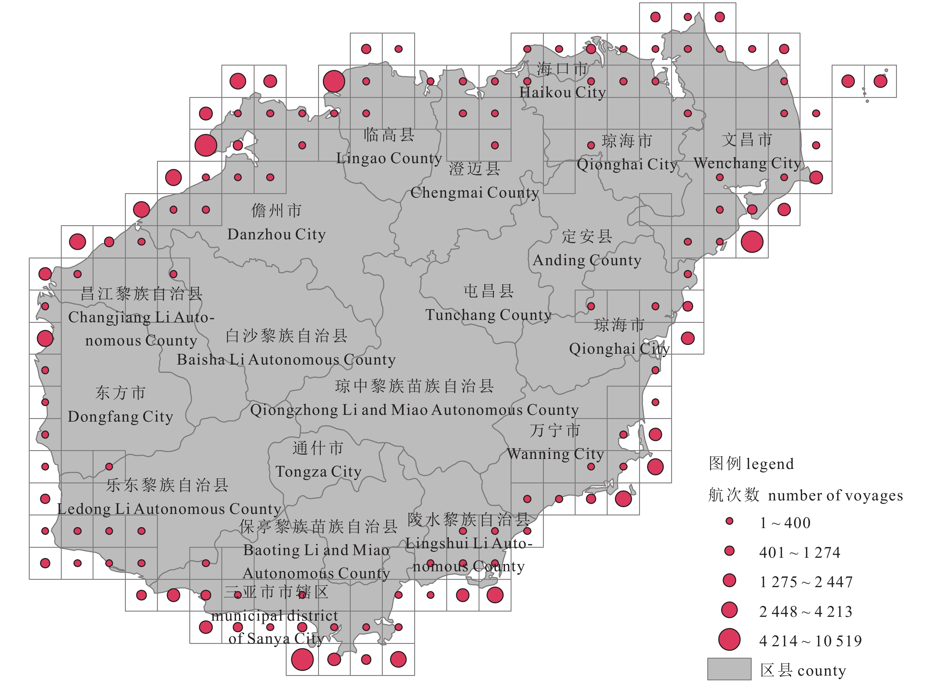
本文港口格网定义为中国海岸线上0.1°×0.1°的格网。首先计算中国地图的外接矩形范围,把这个范围划分为0.1°×0.1°格网;然后把格网图层与海岸线图层叠加,提取出两者相交的港口格网(图1);再计算出港口格网中心点的经度和纬度,把省、地区、县行政区划与港口格网中心点叠加,离中心点最近的行政区划作为其所属的行政区划,定义港口格网数据表,内容包括格网中心点经度、格网中心点纬度,以及港口格网中心点所属的省、地区、县;最后根据港口格网与渔船轨迹相交关系,提取出渔船的出发与返回点,由这两点确定航次的出发与返回港口。
1.2.1 确定格网与渔船轨迹点相交关系
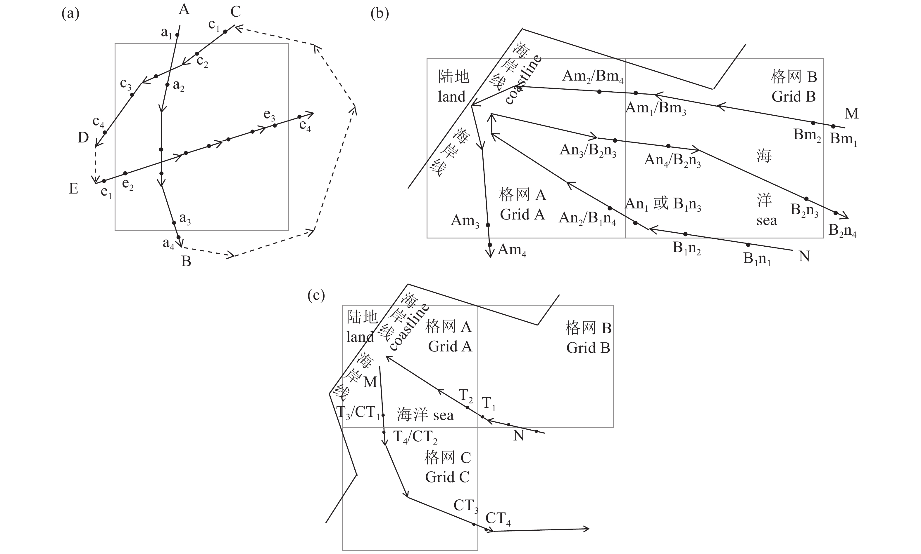
渔船一般3 min一个点,记录的数据包括船名、经纬度、时间、航速、航向,根据船名可以获取一段时间的渔船轨迹点。选择一艘渔船的部分轨迹,按时间先后排序,分析轨迹与格网的关系。渔船轨迹点由A、B、C、D和E 5段组成(图2-a),其中A、C、E 3段与格网相交。每条相交线提取出进入格网前第一个点,如A段的a1点、C段的c1点、E段的e1点;进入格网后第一个点,如A段的a2点、C段的c2点、E段的e2点;出格网前最后一个点,如A段的a3点、C段的c3点、E段的e3点;出格网后第一个点,如A段的a4点、C段的c4点、E段的e4点。
1.2.2 渔船进出港口格网筛选
利用海岸线与港口格网相交关系,得到多个港口格网(图2-b中的格网A、格网B)。一艘渔船先后经过的轨迹线M和N,完成2次进港与出港。M轨迹是渔船完成海上捕捞作业后,先经过港口格网B,然后经过Am1、Am2进入港口格网A,再经过卸载与补给又经过Am3、Am4离开港口格网A;N轨迹是渔船在海上经过一段时间捕捞作业后返回,先经过港口格网B,然后经过An1、An2进入港口格网A,再次卸载与补给后,经过An3、An4离开港口格网A。因此格网A是渔船进出港的实际格网,格网B是渔船到格网A经过的格网。每个格网为0.1°×0.1°,格网宽度小于6 n mile,渔船航速均大于6 kn,渔船经过格网的时间一般小于1 h,而渔船进港卸载与补给时间均大于1 h,因此本文定义渔船进格网点与出格网点的时间差大于1 h,筛选渔船进出的港口格网。
根据渔船轨迹与格网相交关系,提取到每个格网的4个点,如轨迹M进入格网B前第一个点Bm1、进入格网后第一个点Bm2、出格网前最后一个点Bm3、出格网后第一个点Bm4;进入格网A前第一个点Am1、进入格网后第一个点Am2、出格网前最后一个点Am3、出格网后第一个点Am4;轨迹N进入格网B前第一个点B1n1、进入格网后第一个点B1n2、出格网前最后一个点B1n3、出格网后第一个点B1n4,进入格网A前第一个点An1、进入格网后第一个点An2、出格网前最后一个点An3、出格网后第一个点An4,进入格网B前第一个点B2n1、进入格网后第一个点B2n2、出格网前最后一个点B2n3、出格网后第一个点B2n4。在轨迹M上,由Bm1到Bm4,在轨迹N上,由B1n1到B2n4按时间先后顺序排列。
设进入港口格网前第一个点时间为T1、进入格网后第一个点时间为T2、出格网前最后一个点时间为T3、出格网后第一个点时间为T4。一艘船一年的轨迹点,在经过港口格网提取后,再按T2~T3、T1~T3、T2~T4、T1~T4计算时间,进格网点与出格网点的时间差大于1 h,渔船进入格网点后第一个点与出格网前最后一个点的时间差来判断是否为渔船进出港口的格网。在图2-b港口格网A中,计算Am3与Am2、An3与An2的时间差;在港口格网B中,计算B1n3与B1n2、B2n3与B2n2、Bm3与Bm2的时间差。由于港口格网A中有卸载与补给时间,因此时间差会大于1 h;港口格网B中是经过,因此时间差会小于1 h,这样就排除了港口格网B。
1.2.3 渔船出进港口数据提取
经过“渔船进出港口格网筛选”后可能存在非渔船进出港口格网没有被去掉的情况,需要作进一步的筛选处理。渔船经过出港,然后进行海上作业,再进港,完成一次完整的作业过程一般都在0.5 d以上,且渔船经过港口格网时间一般小于1 h,通过离开港口格网的时间与进港口的时间差计算出海作业的时间,判断格网是否为渔船进出港口格网。
图2-c中有格网A、格网B和格网C 3个港口格网,假设渔船由格网A出港,经格网C出海作业,最后由格网A返港。格网B在“渔船进出港口格网筛选”过程中被排除,格网C没有被排除。在每个格网中都能提取到一条进格网和出格网的记录,格网A中的进出港口格网是渔船实际的出港与返港。可以选择T4~T1、T4~T2、T3~T1和T3~T2中的一个用于计算时间差(本文选用T4~T2作为时间差),时间差大于0.5 d作为一次出港和进港。当渔船驶出再返回格网A时,由于渔船出海时间较长,T4~T2计算的时间大于0.5 d;当渔船经过格网C航行出海时航速较大,CT2~CT4计算的时间差小于0.5 d,通过计算时间差排除格网C。把进出港口格网信息,包括船名、出格网中心点经纬度、出格网时间、出格网经纬度、进格网时间、进格网中心点经纬度、进格网经纬度、出海作业天数,写入“渔船进出港口格网数据表”。
2. 结果
航次数据字段包括出发港口格网的中心点经纬度、出发时间、出发时记录的第一个船位点的经纬度,返回港口格网的中心点经纬度,返回时间、返回时记录的最后一个船位经纬度,以及出海船名和航次时间长度。海南省海域面积约200×104 km2,作为渔业大省其渔船数量众多,航次具有很好的代表性,且海南省的岛屿相比其他沿海省份较少,行政区划较为简单,因此以海南为例进行分析。海南渔船航次有3种情况:1)海南渔船出海后返回海南;2)非海南渔船出海后返回海南;3)海南渔船出海后返回非海南港口。本文把航次时间设定为1~30 d。
2.1 不同渔船类型的航次
海南渔船作业类型与航次关系和统计见表1。其中“渔船数”来自中国渔业统计年鉴,“平均吨位”和“平均功率”由统计年鉴中的数据计算获得。渔船中仅有部分硬件设施较好的渔船安装了北斗终端,并且有北斗终端的渔船中仅少量收集到作业类型数据,通过不同作业类型渔船的航次统计出航次的累计天数和航次数据,并计算出航次的平均天数,拖网、灯围钓业、张网、杂渔具航次时间为5 d左右,刺网、笼壶为15 d左右。
表 1 渔船类型与航次Table 1 Fishing vessel types and voyages渔船类型
fishing type渔船数*
number of vessel平均吨位*
average tonnage平均功率/kW*
average power航次数
number of voyages累计天数/d
cumulative days平均天数/d
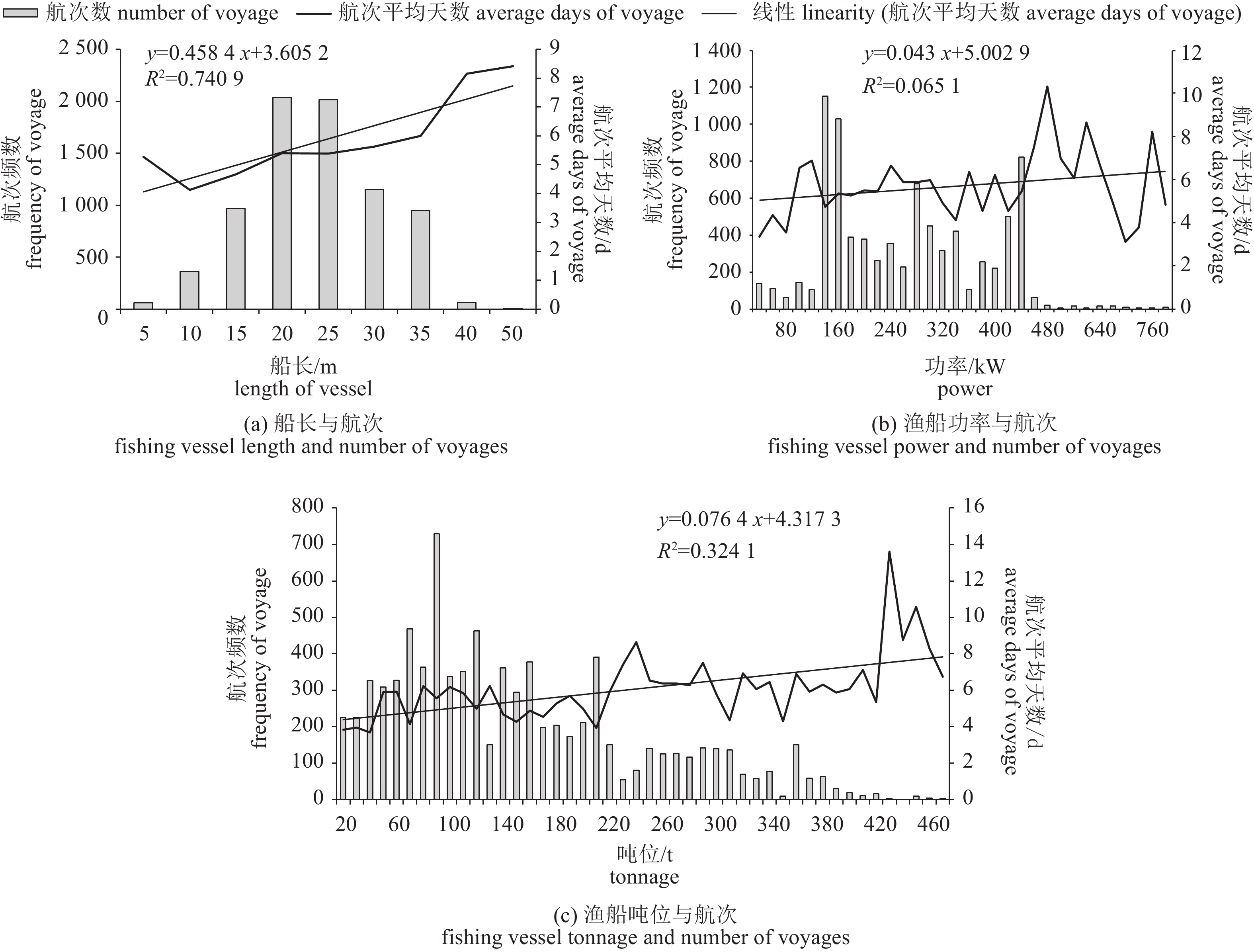
average days拖网 trawl 1 738 74.7 154.5 3 923 21 030.6 5.4 灯围 light seine 3 146 39.2 83.4 178 752.1 4.2 钓业 hook fishing 2 850 11.7 37.5 141 981.5 7.0 刺网 gill net 14 952 13.9 44.4 23 324.5 14.1 张网 Zhang Wang 1 548 7.5 25.6 20 92.8 4.6 笼壶 pot 20 352.5 17.6 杂渔具 miscellaneous fishing gear 1 342 9.3 27.9 114 646.2 5.7 注:*. 来自2017年《中国渔业统计年鉴》的统计数据,年鉴中没有统计笼壶,本文统计的航次数仅为部分作业渔船的数据 Note: *. The data are derived from the 2017 China Fisheries Statistics Yearbook. There are no statistics on the cage pot in the Yearbook. The number of voyages is only part of the data for some fishing vessels in this paper. 渔船长度从5~50 m、按间隔5 m划分9个等级(图3-a),航次频数在20~25 m和25~30 m最高,随渔船长度增加,航次平均天数从4 d增加至8 d,拟合趋势线为y=0.458 4x+3.602 52,R2为0.740 9;渔船功率从40~780 kW、按间隔20 kW划分37个等级(图3-b),航次频数集中在140~440 kW,随渔船功率增大,航次平均天数波动较大,线性拟合趋势线为y=0.043x+5.002 9,R2为0.065 1;渔船吨位从20~470 t、按间隔10 t划分45个等级(图3-c),航次频数集中在20~210 t,随渔船功率增大,航次平均天数波动较大,但随吨位增大逐渐增加,线性拟合趋势线为y=0.076 4x+4.317 3,R2=0.324 1。
2.2 返回港口为海南的航次统计
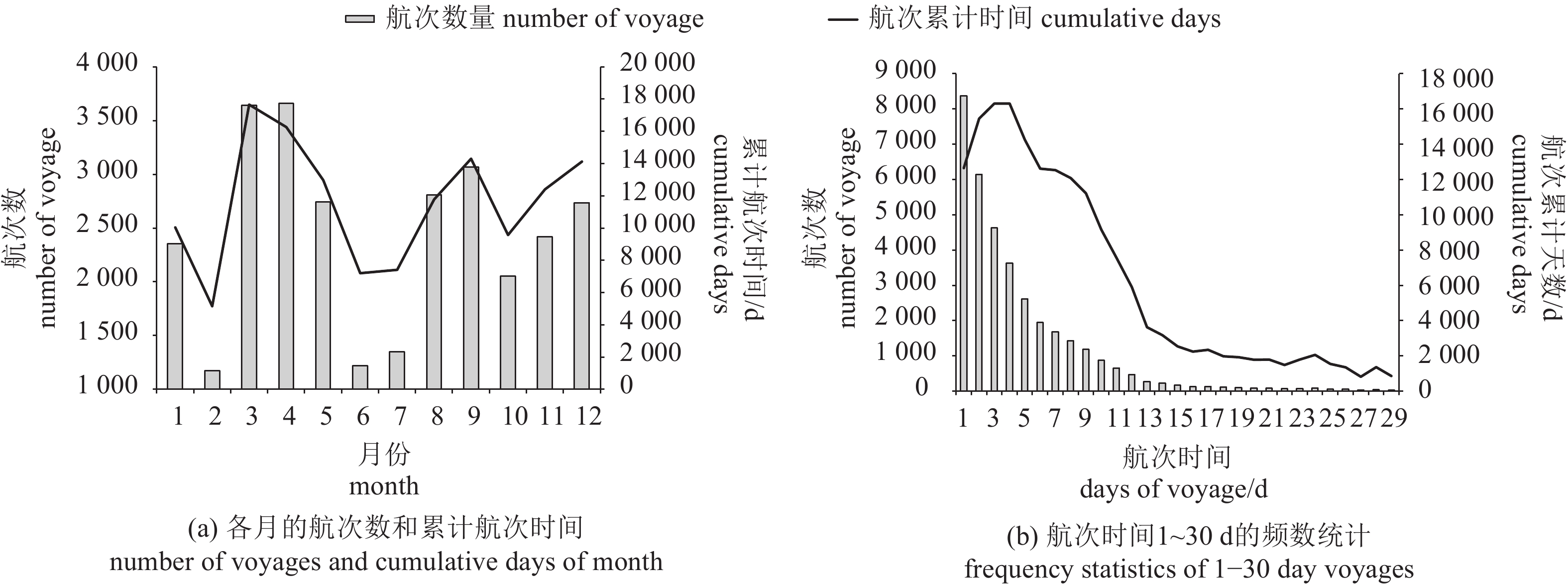
航次的累计时间存在明显的峰值与谷值(图4-a),3个峰值分别在3—4月、8—9月和12月,3个谷值分别在2月、6月和10月。选择渔船返回港口为海南省的航次,根据航次时间统计2016年航次时间长度为1~30 d的频数,统计结果可以分为3组(图4-b):航次时间长度1~9 d,频次1 000~8 300次;航次时间长度10~18 d,频次100~1 000次;航次时间长度19~30 d,频次29~100次。
2.3 返回海南各港口的航次统计
返回港口为海南的航次是海南渔船出海后返回海南与非海南渔船出海后返回海南这2种情况下的航次数据。海南沿海县市有昌江黎族自治县(昌江)、澄迈县(澄迈)、东方市(东方)、海口市(海口)、乐东黎族自治县(乐东)、临高县(临高)、陵水黎族自治县(陵水)、琼海市(琼海)、三亚市(三亚)、万宁市(万宁)、文昌市(文昌)、儋州市(儋州)。航次数比较多的是文昌、三亚、儋州(5 000~9 000个航次);其次是陵水、万宁、东方、昌江、临高、海口(1 500~2 500个航次);澄迈、乐东、琼海航次均在1 000个以下(表2)。
表 2 返港港口在海南的航次Table 2 Return voyages in Hainan port县市
country & city海南出港海南进港
departure from & return to Hainan非海南出港海南进港
not departure from & return to Hainan航次数合计
total number of voyage航次数
number of voyage累计天数
cumulative days平均天数
average days航次数
number of voyage累计天数
cumulative days平均天数
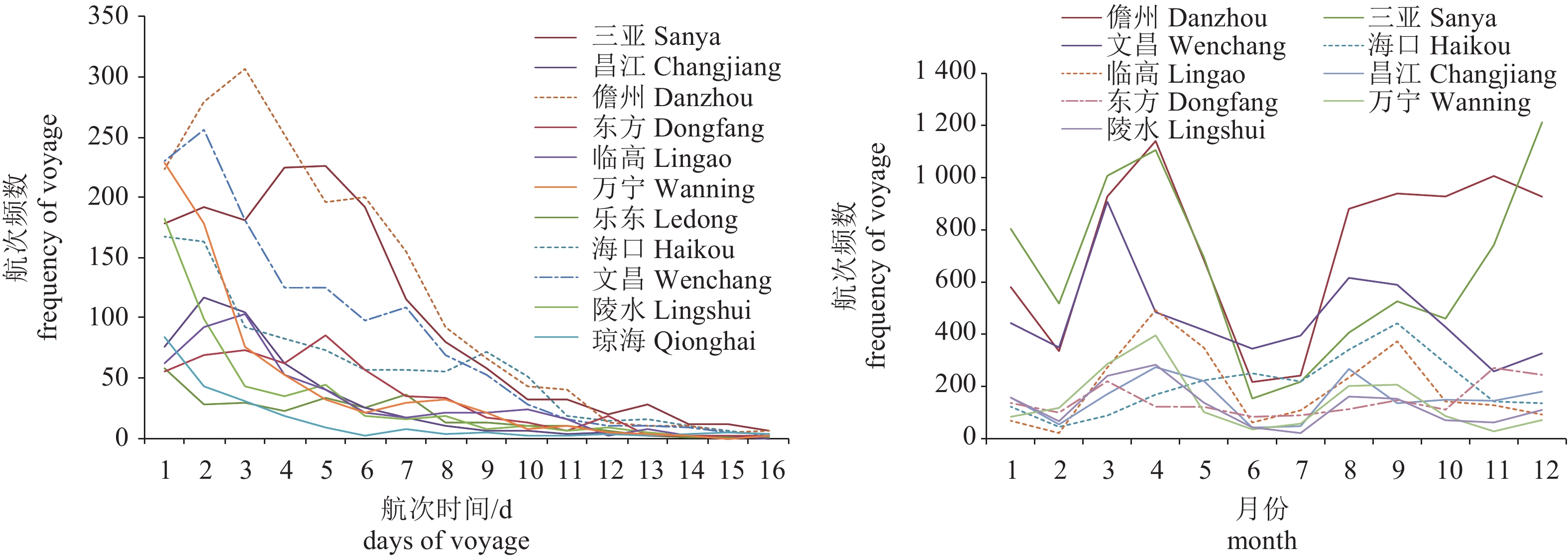
average days澄迈 Chengmai 17 54 3.2 2 3 1.4 19 乐东 Ledong 508 2 175 4.3 137 979 7.1 645 琼海 Qionghai 770 5 678 7.4 18 101 5.6 788 陵水 Lingshui 1 422 4 565 3.2 99 671 6.8 1 521 万宁 Wanning 1 288 4 076 3.2 399 1 584 4.0 1 687 东方 Dongfang 1 486 7 432 5.0 288 1 985 6.9 1 774 昌江 Changjiang 1 683 6 226 3.7 175 846 4.8 1 858 临高 Lingao 2 157 8 428 3.9 198 1 578 8.0 2 355 海口 Haikou 1 824 10 801 5.9 657 4 915 7.5 2 481 文昌 Wenchang 4 620 22 337 4.8 949 4 852 5.1 5 569 三亚 Sanya 7 169 38 048 5.3 687 5 230 7.6 7 856 儋州 Danzhou 6 282 29 135 4.6 2 534 17 162 6.8 8 816 返回海南各区县的不同航次的时间频数峰值存在差别(图5-a)。万宁、陵水、琼海、乐东的以1 d航次频数为峰值;文昌、海口、昌江的以2 d航次频数为峰值;儋州、临高的以3 d航次频数为峰值;三亚、东方的以5 d航次频数为峰值。渔船返回港为海南的航次在1 500个以上的区县中,除海口在9月有一个峰值外,其他区县都有2个峰值,分别在3月、4月和5月、8月和9月,三亚在12月还有1个峰值(图5-b)。
2.4 海南出港非海南进港的航次统计
一些渔船的作业航次由海南出港但没有返回海南,航次数量前10的非海南区县见表3。北海市和阳江市均超过1 000个航次,惠州市、电白县、防城区均超过100个航次,阳东县、台山市、浈江区、阳西县、徐闻县均在100个航次以下。
表 3 海南出港非海南进港的航次Table 3 Hainan departure and non-Hainan return voyage序号
NO.县市
country & city航次数
number of voyage累计天数
cumulative days平均天数
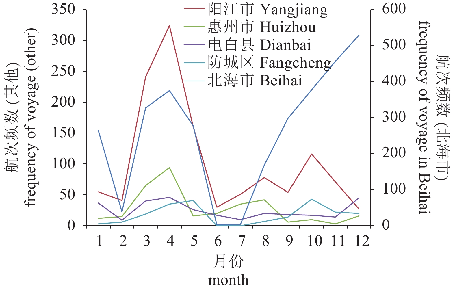
average days1 北海市 Beihai 3 119 22 363 7 2 阳江市 Yangjiang 1 249 9 257 7 3 惠州市 Huizhou 334 2 876 9 4 电白县 Dianbai 299 1 568 5 5 防城区 Fangcheng 210 1 202 6 6 阳东县 Yangdong 92 476 5 7 台山市 Taishan 91 675 7 8 浈江区 Zhenjiang 75 268 4 9 阳西县 Yangxi 52 286 6 10 徐闻县 Xuwen 43 190 4 渔船由海南出但非海南返回,航次在200个以上的其他区县中,北海市、电白县峰值在4月和12月,惠州市峰值在4月和8月(图6)。
3. 讨论
3.1 海南不同类型渔船作业航次特点
海南是渔业大省,管辖海域面积约200×104 km2,周围有北部湾、三亚、青澜三大渔场,鱼类品种多、生长快、渔汛期长,2016年捕捞产量为140.7×10⁴ t[26]。全省以木质渔船占绝大多数,新型玻璃钢、钢质机动渔船数量占小部分,大部分是船龄在10年以上的木质机动渔船[27]。海南安装有北斗终端、并在2016年有船位记录的渔船有12 402艘,仅部分渔船收集到了作业类型,以及渔船的长度、功率和吨位等数据。海南刺网渔船数量最多,占总船数的58.5%;其次是围网和钓具,分别占12.3%和11.1%;第三是拖网和张网,分别占6.7%和6%;杂渔具仅占5.2%。拖网渔船虽然数量少,但大多为硬件条件好的大型渔船,北斗终端安装率高;其次是灯光围网渔船,吨位与功率都较大,也有较高的北斗终端安装比例;刺网、钓业和张网由于渔船较小,硬件条件差,安装北斗终端的渔船比例小。从统计数据来看,刺网、笼壶航次的时间较长(15 d),其他作业类型航次时间约5 d。
海南渔船以小型为主,从长度来看,12 m以下有20 462艘,占总数的78.6%;12 (含)~24 m有4 569艘,占总数的17.9%;24 m (含)以上仅993艘。从功率来看,44.1 kW以下20 665艘,占总数的80.8%;44.1 (含)~441 kW有4 774艘,占总数的18.7%;441 kW (含)以上仅138艘[22]。小型渔船主要在海南附近渔场作业,航次都较短,其中航次时间1~5 d占全部航次数的71.8%;航次时间长度1~9 d占全部航次数的89.4%。渔船在长度、功率、吨位的航次频数差别较大,峰值分别出现在20~30 m、140~440 kW、20~210 t。航次时长随渔船长度、功率、吨位的增大而增多,主要由于较大的渔船硬件条件好,更能适应复杂的海况和天气条件,能够航行到较远的渔场,因此航次天数较长。
3.2 2016年各月份航次频数变化大
受休渔期、节假日以及冷空气、大风或台风天气的影响,月航次频数变化大。1月受冷空气影响的时间较长,海上风浪大,大部分渔船停止生产,在码头修机、补网等待过年,少部分渔船偶尔出港试捕,近海作业的小流刺网、小钓业渔船等也因天气状况差,作业时间相对减少,航次频数不高;2月受冷空气影响,海上风浪大,2月7日—2月13日又正值农历春节,渔船出海时间比较少,因此2月航次频数出现谷值;3月气温回升,4月气温较高,各种捕捞方式在大部分时间都可正常生产,这2个月航次频数最高;自5月16日12时起至8月1日12时止是实施南海伏季休渔制度的第18年[28],休渔期间除单层刺网、钓具外,禁止其他作业类型生产,因此6月和7月航次频数出现谷值,5月只生产作业半个月,航次频数也不高;8月是休渔期结束后的第一个月,渔船刚开始出港作业,航次频数开始增大;10月受第19号台风“艾利”和第21号超强台风“莎莉嘉”的先后影响,渔船生产时间减少,且10月1日至10月7日为国庆节,因此10月航次频数也较低;11月气温有所下降,冷空气开始南下,12月受冷空气影响,海上风浪大,大型灯光渔船大部分停止生产,小型灯光渔船在近岸生产时间有所减少,但这2个月航次频数仍较高。
3.3 航次集中在几个主要港口
近海渔港多,各港口基础条件差别大,若渔获上报分散在各港口,难于管理,渔获数据质量不能保证,因此可以选定航次集中的几个港口作为限额捕捞数据上报点。海南省“十二五”期间形成了北有海口港、南有三亚港、西有洋浦港和八所港、东有清澜港的“四方五港”格局,2016年儋州白马井、琼海潭门、东方八所、临高新盈等中心渔港完成一期工程建设并投入使用。海南“十三五”拟选址三亚崖州中心渔港、文昌铺前中心渔港作为示范中心渔港建设试点,目前,三亚崖州中心渔港二期、儋州市白马井中心渔港概念性升级改造、东方八所中心渔港升级改造都在进行中。从2016年返回港在海南的航次来看,主要集中在几个港口,如儋州、三亚、文昌、海口、临高,前3个县市的航次占海南航次总数的62.9%,前5个县市的航次占海南航次总数的76.6%,因此渔获上报可以限定在航次比例大的儋州白马井、三亚港、文昌清澜港、海口港、临高新盈等港口。返回海南各区县的不同航次的时间频数差别比较大,渔船返回港为海南的航次在各月频数分布也不同,不同港口、不同时间渔获上报量波动会比较大。海南出港非海南进港的航次主要集中在附近的广东省和广西壮族自治区的县市,如北海市、阳江市、惠州市;非海南进港的航次较少,仅占海南航次总数的13.9%,航次各月频次集中在4月、8月和12月。
4. 小结与展望
基于北斗的VMS最初是为了渔船管理和渔船安全而建立,能监督渔船海上捕捞的全过程,定位渔船是否位于禁渔区或限定捕捞的协定区[26];VMS还记录了航速、航向等信息,通过这些数据挖掘还可提取渔船作业状态、追溯渔船渔获、判断渔船捕捞行为是否违规等,为海洋渔业限额捕捞提供有利的技术手段。我国正逐步施行海洋捕捞限额管理政策,完善的渔获统计报告制度将是实现配额的前提[29],VMS技术可以提升渔获上报的准确率,为科学的资源评估提供有力保障。
本文先定义海陆边界的港口格网,然后根据格网与渔船轨迹的相交关系,提取海南2016年全部航次,最后统计出不同类型渔船的航次特点,不同时间各港口航次的变化,以及航次集中的主要港口。限额捕捞可以限定当前返回航次多的渔港为渔获上报点,每个县市可设一个,统计各渔港的航次情况,可以估算捕捞量,用于验证上报渔获的准确性。根据渔船的航次估算每艘渔船的渔获,监督渔船的上报数据,准确掌握渔船各类违规数据。在配额捕捞量限定后,根据VMS统计数据,可及时调整配额量,使总可捕量控制在允许的捕捞范围内。VMS积极有效的海上渔船捕捞航次监督[30-31],可降低非法捕捞事件以及瞒报、错报配额捕捞数据的问题,降低了渔业管理成本,提高了渔业管理效率,有益于渔业资源的养护和管理。
然而,把基于北斗的VMS应用于捕捞限额管理也存在一些缺陷。1) 我国小型渔船比重大,有条件安装北斗终端的渔船都已安装,但北斗渔船终端安装比例仍然有限,约占渔船总量的30%,因此仅对部分渔船实现了监管;2) 渔船北斗终端在设备故障、供电不足、信号干扰、人为关闭等因素下,船位数据不能发回或数据错误,都会影响正常的监管;3) 我国渔船作业类型不固定,根据捕捞许可规定,渔船最多上报2种作业类型,但实际作业时类型变化较大,影响了数据统计的准确性。随着我国拆小并大、老旧船淘汰等工作的进展,北斗终端普及率会逐渐提高,北斗终端软硬件技术的进步也会减少设备的故障率,国家对限额捕捞的重视,以及相关法律法规的完善,完全可以消除人为关闭北斗终端的现象。北斗船位数据挖掘技术的发展,将能判断出短期内渔船作业类型的变化,挖掘出更多服务于限额捕捞的有价值的信息。
-
表 1 渔船类型与航次
Table 1 Fishing vessel types and voyages
渔船类型
fishing type渔船数*
number of vessel平均吨位*
average tonnage平均功率/kW*
average power航次数
number of voyages累计天数/d
cumulative days平均天数/d
average days拖网 trawl 1 738 74.7 154.5 3 923 21 030.6 5.4 灯围 light seine 3 146 39.2 83.4 178 752.1 4.2 钓业 hook fishing 2 850 11.7 37.5 141 981.5 7.0 刺网 gill net 14 952 13.9 44.4 23 324.5 14.1 张网 Zhang Wang 1 548 7.5 25.6 20 92.8 4.6 笼壶 pot 20 352.5 17.6 杂渔具 miscellaneous fishing gear 1 342 9.3 27.9 114 646.2 5.7 注:*. 来自2017年《中国渔业统计年鉴》的统计数据,年鉴中没有统计笼壶,本文统计的航次数仅为部分作业渔船的数据 Note: *. The data are derived from the 2017 China Fisheries Statistics Yearbook. There are no statistics on the cage pot in the Yearbook. The number of voyages is only part of the data for some fishing vessels in this paper. 表 2 返港港口在海南的航次
Table 2 Return voyages in Hainan port
县市
country & city海南出港海南进港
departure from & return to Hainan非海南出港海南进港
not departure from & return to Hainan航次数合计
total number of voyage航次数
number of voyage累计天数
cumulative days平均天数
average days航次数
number of voyage累计天数
cumulative days平均天数
average days澄迈 Chengmai 17 54 3.2 2 3 1.4 19 乐东 Ledong 508 2 175 4.3 137 979 7.1 645 琼海 Qionghai 770 5 678 7.4 18 101 5.6 788 陵水 Lingshui 1 422 4 565 3.2 99 671 6.8 1 521 万宁 Wanning 1 288 4 076 3.2 399 1 584 4.0 1 687 东方 Dongfang 1 486 7 432 5.0 288 1 985 6.9 1 774 昌江 Changjiang 1 683 6 226 3.7 175 846 4.8 1 858 临高 Lingao 2 157 8 428 3.9 198 1 578 8.0 2 355 海口 Haikou 1 824 10 801 5.9 657 4 915 7.5 2 481 文昌 Wenchang 4 620 22 337 4.8 949 4 852 5.1 5 569 三亚 Sanya 7 169 38 048 5.3 687 5 230 7.6 7 856 儋州 Danzhou 6 282 29 135 4.6 2 534 17 162 6.8 8 816 表 3 海南出港非海南进港的航次
Table 3 Hainan departure and non-Hainan return voyage
序号
NO.县市
country & city航次数
number of voyage累计天数
cumulative days平均天数
average days1 北海市 Beihai 3 119 22 363 7 2 阳江市 Yangjiang 1 249 9 257 7 3 惠州市 Huizhou 334 2 876 9 4 电白县 Dianbai 299 1 568 5 5 防城区 Fangcheng 210 1 202 6 6 阳东县 Yangdong 92 476 5 7 台山市 Taishan 91 675 7 8 浈江区 Zhenjiang 75 268 4 9 阳西县 Yangxi 52 286 6 10 徐闻县 Xuwen 43 190 4 -
[1] LEE D, JEONG S, KIM S, et al. Analysis of cost effectiveness on fishing trip cost by adopting photovoltaic power generation system in a small fishing vessel[J]. J Fish Mar Educ, 2017, 29(5): 1470-1479.
[2] 张效嘉, 线薇微. 1985~1986年长江口生态系统能流网络分析[J]. 海洋科学, 2016, 40(7): 60-72. [3] 高健, 张相国. 帆式张网渔业经济效益与渔业生产[J]. 中国渔业经济, 2001(5): 26-28. [4] 张晓辉. 基于动态信息的程租航次效益测算系统[J]. 水运管理, 2015, 37(12): 4-6. [5] 赖禄元, 郑满. 经济航速——提高航次效益的有效途径[J]. 世界海运, 2016, 39(03): 15-19. [6] 管伟, 徐兆礼, 严太亮. 福建中部近海鱼类生态类群的季节变化[J]. 水产学报, 2017, 41(4): 535-546. [7] 许友伟, 江艳娥, 范江涛, 等. 南海中部海域秋冬季中层渔业生物群落结构的初步研究[J]. 南方水产科学, 2016, 12(4): 49-56. [8] 李德源, 杨培军. 不定期船航次估算的风险概率决策研究[J]. 大连海事大学学报, 1999, 25(4): 36-39. [9] 徐荣, 蒋志明. 航次估算辅助决策系统的研制与应用[J]. 交通与计算机, 1992(6): 55-57. [10] WATSON J T, HAYNIE A C. Using vessel monitoring system data to identify and characterize trips made by fishing vessels in the United States North Pacific[J]. PLoS One, 2016, 11(10): e0165173.
[11] 张胜茂, 程田飞, 王晓璇, 等. 基于北斗卫星船位数据提取拖网航次方法研究[J]. 上海海洋大学学报, 2016, 25(1): 135-141. [12] 林丕文, 邹建伟. 我国当前南海南部拖网渔业的困局和对策[J]. 渔业信息与战略, 2014, 29(3): 172-177. [13] 林晓松, 林少芬. 基于Linux和CDMA的AIS数据传输系统[J]. 集美大学学报(自然科学版), 2015, 20(3): 198-202. [14] 何伟, 柳晨光, 石磊, 等. 渔业生产安全保障远程管理系统[J]. 武汉工程大学学报, 2014, 36(11): 63-69. [15] 郑巧玲, 樊伟, 张胜茂, 等. 基于神经网络和VMS的渔船捕捞类型辨别[J]. 南方水产科学, 2016, 12(2): 81-87. [16] 张胜茂, 程田飞, 化成君, 等. 北斗卫星数据提取耙刺渔船作业状态方法研究[J]. 渔业信息与战略, 2015, 30(4): 293-300. [17] POLOCZANSKA E. Keeping watch on the ocean[J]. Science, 2018, 359(6378): 864-865.
[18] 张胜茂, 唐峰华, 张衡, 等. 基于北斗船位数据的拖网捕捞追溯方法研究[J]. 南方水产科学, 2014, 10(3): 15-23. [19] ZHANG S, JIN S, ZHANG H, et al. Distribution of bottom trawling effort in the Yellow Sea and East China Sea[J]. PLoS One, 2016, 11(11): e0166640.
[20] AULINGER A, MATTHIAS V, ZERETZKE M, et al. The impact of shipping emissions on air pollution in the greater North Sea region - Part 1: current emissions and concentrations[J]. Atmos Chem Phys, 2016, 16(2): 739-758.
[21] 张胜茂, 张衡, 唐峰华, 等. 基于船位监控系统的拖网捕捞努力量提取方法研究[J]. 海洋科学, 2016, 40(3): 146-153. [22] NATALE F, GIBIN M, ALESSANDRINI A, et al. Mapping fishing effort through AIS data[J]. PLoS One, 2015, 10(6): e0130746.
[23] VYSHNEVSKA O, VISHNEVSKY D. Investigation of the effect of ship size and marine transportation distance on the possible decrease of voyage efficiency[J]. Інформаційно-керуючі системи, 2017, 33(1/2): 38-44.
[24] LONG J M, MELSTROM R T. Measuring the relationship between sportfishing trip expenditures and anglers' species preferences[J]. N Am J Fish Manag, 2016, 36(4): 731-737.
[25] 农业部渔业渔政管理局. 中国渔业统计年鉴[M]. 北京: 中国农业出版社, 2017: 72-74. [26] 应验. 海南海洋渔业发展方向与对策研究[J]. 海南热带海洋学院学报, 2017, 24(6): 24-29. [27] 许倩, 翁绍捷, 李严. 海南省机动渔船能耗及碳排量的调查与研究[J]. 热带农业工程, 2017, 41(3): 20-25. [28] 刘禹松, 雷声. 伏季休渔助力海南渔业稳中向好[J]. 新产经, 2016(7): 62-63. [29] 闫海, 刘若冰. 我国海洋渔业限额捕捞法制的症结及对策[J]. 青岛科技大学学报(社会科学版), 2015, 31(3): 75-78. [30] KROODSMA D A, MAYORGA J, HOCHBERG T, et al. Tracking the global footprint of fisheries[J]. Science, 2018, 359(6378): 904-908.
[31] RUSSO T, CARPENTIERI P, FIORENTINO F, et al. Modeling landings profiles of fishing vessels: an application of self-organizing maps to VMS and logbook data[J]. Fish Res, 2016, 181(9): 34-47.
-
期刊类型引用(12)
1. 孙慧岩,周艳波,马胜伟,田骥,徐景春,刘智瑛,毕洁婷,吴洽儿. 基于北斗船位数据的南海外海灯光罩网渔船作业特征研究. 南方水产科学. 2023(02): 21-30 .  本站查看
本站查看
2. 孙永文,张胜茂,唐峰华,王书献,樊伟,范秀梅,杨胜龙. 基于卫星船位数据的北太平洋作业渔船分布及类型研究. 中国农业科技导报. 2022(08): 207-217 .  百度学术
百度学术
3. 钱静,李佳俊,陈作志,马胜伟,张鹏,邱永松,蔡研聪. 基于北斗船位数据的南海大型灯光罩网渔业研究. 南方水产科学. 2022(06): 1-9 .  本站查看
本站查看
4. 李国东,仲霞铭,熊瑛,龚海翔,汤建华,施金金,吴磊. 基于北斗船位数据的渔业信息解译与应用研究——以中国毛虾限额捕捞管理为例. 海洋与湖沼. 2021(03): 746-753 .  百度学术
百度学术
5. 于杰,周艳波,唐振朝,陈国宝,曾雷. 基于北斗卫星船位监控系统数据的南海双拖渔船作业特征研究. 海洋科学. 2021(10): 40-48 .  百度学术
百度学术
6. LI Qi,SUN Dongzhi,SUN Tianyang,MA Yinhu,REN Yu. “北斗+”应用发展最新趋势分析与建议(英文). Aerospace China. 2021(03): 42-45 .  百度学术
百度学术
7. 汤先峰,张胜茂,樊伟,裴凯洋. 基于北斗船位数据的江苏渔船航次分析. 渔业现代化. 2020(01): 63-71 .  百度学术
百度学术
8. 汤先峰,张胜茂,樊伟,裴凯洋. 基于深度学习的刺网与拖网作业类型识别研究. 海洋渔业. 2020(02): 233-244 .  百度学术
百度学术
9. 张红漓. 基于北斗卫星系统港口船位数据的拖网规划方法. 舰船科学技术. 2020(18): 208-210 .  百度学术
百度学术
10. 裴凯洋,张胜茂,樊伟,侯娟,汤先峰,朱文斌. 浙江省帆张网捕捞强度分布的提取方法. 水产学报. 2020(11): 1913-1925 .  百度学术
百度学术
11. 张胜茂. 拖网对海底环境压力评价方法分析. 安徽农业科学. 2019(20): 57-60 .  百度学术
百度学术
12. 冯菲,周艳波,陈森,谢恩阁,吴洽儿. 拖网渔船电子捕捞日志的作业信息与北斗船位数据获取的作业信息的可信度比较研究. 南方水产科学. 2019(06): 65-74 .  本站查看
本站查看
其他类型引用(11)


 下载:
下载:
 粤公网安备 44010502001741号
