Fishery forecast research of purpleback flying squid in Nansha area based on Habitat model
-
摘要:
栖息地模型是渔情预报的重要方法之一,具有应用范围广,预报精度高的特点。根据“南锋”号调查船2013年春夏秋冬4个季节对南沙海域鸢乌贼(Sthenoteuthis oualaniensis)的声学调查数据,结合遥感所获得的环境数据,将鸢乌贼生物量作为适应性指数,利用最大值法、最小值法、几何平均值法和算数平均值法分别建立基于表温(SST)、叶绿素a浓度(CHL)、海表盐度(SSS)和海面高度(SSH)的综合栖息地指数(habitat suitability index, HSI)模型。结果表明算数平均值法拟合效果最好,模型准确度达75%以上,生物量高的区域主要分布在HSI大于0.5的海域,其他HSI较高的海域可能为潜在渔场。
Abstract:The habitat model is one of the important methods of fishery forecasting, which is highly applicable and accurate. According to the survey data of "Nanfeng" Fishery Research Vessel collected from Nansha Islands waters in 2013 in addition to data of acoustic navigation and environmental data from remote sensing, we applied biomass as adaptive index and established the sea surface temperature (SST) model based on concentration of Chlorophyll a (CHL), sea surface height (SSH) and sea surface salinity (SSS) by using maximum value method, minimum value method, geometric mean value method and arithmetic mean value method. The result shows the arithmetic mean value fits the best. The accuracy of the model was above 75%. The area of high biomass mainly distributed in the area of high HSI which was more than 0.5. The other areas of high HSI might be potential fishing grounds.
-
Keywords:
- Sthenoteuthis oualaniensis /
- Nansha area /
- habitat areas /
- fishery forecast model
-
鸢乌贼(Sthenoteuthis oualaniensis)属头足纲,柔鱼科,鸢乌贼属,广泛分布于热带、亚热带海域,具有生长周期短,资源储量大等特点[1]。中国南海蕴藏丰富的鸢乌贼资源,据调查南海鸢乌贼的年可捕量为(130~200)×104 t,其中南沙海域90×104 t以上[2-3]。
渔情预报研究通过对生产或调查数据的分析,结合环境数据,采用不同的数学方法,建立二者的联系,从而达到渔情预报的目的[4]。栖息地指数(habitat suitability index, HSI)模型通过模拟生物对不同环境因子反应,可以较为真实地反映和解释渔场的变化[5-6]。近年来中国对鸢乌贼的研究逐渐增多,但主要集中于基础生物学[7-8]、种群结构[9]等生物学方面,对其与海洋环境的关系研究也多集中于一两个因子[10-13],未能综合考虑多种海洋环境因子的共同影响,为此该研究以“南锋”号渔业资源调查结果,综合多种环境因素,构建其HSI模型,以为南海鸢乌贼渔业的可持续发展提供科学依据和理论基础。
1. 材料与方法
1.1 渔场与环境数据
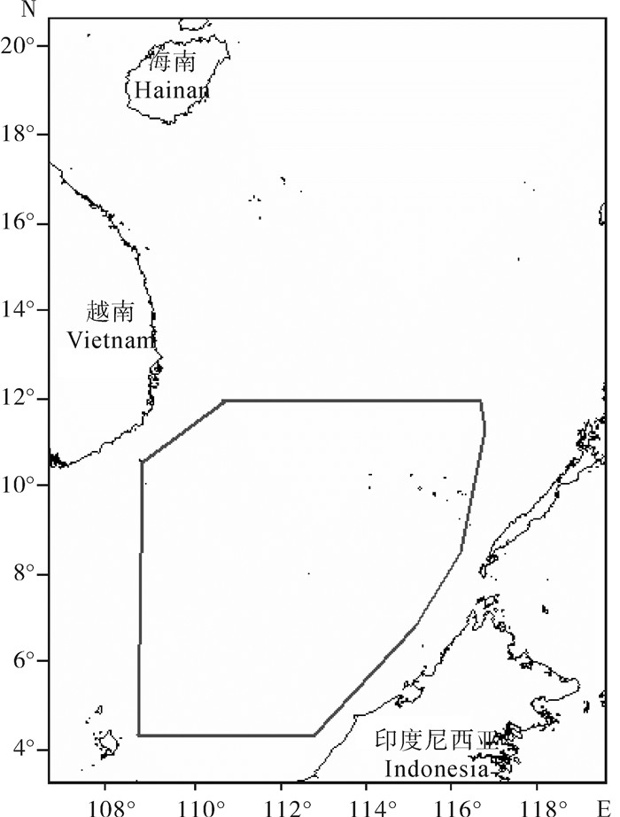
渔场数据来自“南锋”号调查船2013年南沙海域4个季度的调查,以声学走航探测所得生物量数据作为渔场好坏的指标[14],探测设备为Simrad EK60,探测500以上水层,换能器频率为38 kHz,发射功率为2 kW,脉冲宽度1 ms。调查区域见图 1。
环境数据来自美国国家航空航天局(NASA),包括海表面温度(SST)、海面高度(SSH)、叶绿素a浓度(CHL)、海表盐度(SSS)等,选取声学探测当天的数据,空间分辨率为0.1°×0.1°。
1.2 数据处理方法
利用生物量分别与SST、SSH、CHL、SSS来建立相应的适应性指数(SI)模型。文章假设声学评估生物量最多的海域,Ymax认定其HSI为1;生物量为0时,鸢乌贼资源分布较少的海域,认定其HSI为0[4]。渔场数据的80%用于建立模型,剩余20%用于模型的验证。单因素栖息地指数SI计算公式如下:
$$ \mathrm{SI}=\frac{Y}{Y_{\max }} $$ 式中SI为该季度得到的适应性指数;Ymax为该季度调查的生物量最大值。
1.3 栖息地模型
通过一元非线性回归[15-16],建立各环境因子与SI之间的关系模型,分别采用最大值法、最小值法、算数平均法、几何平均法建立HSI模型,并分别带入剩余20%的渔场数据进行验证,理论值与实际值之差小于0.4,即认为预报准确,否则认为预报不准确[17]。采用Marine Explorer 4.0分不同季节进行作图,以验证模型效果。模型表达式为:
最大值法$\mathrm{HSI}=\max \left(\mathrm{SI}_{\mathrm{SST}}, \quad \mathrm{SI}_{\mathrm{SSH}}, \quad \mathrm{SI}_{\mathrm{CHL}}, \quad \mathrm{SI}_{\mathrm{SSS}}\right) $
最小值法${\rm{HSI}} = \min \left( {{\rm{S}}{{\rm{I}}_{{\rm{SST}}}}, \quad {\rm{S}}{{\rm{I}}_{{\rm{SSH}}}}, \quad {\rm{S}}{{\rm{I}}_{{\rm{CHL}}}}, \quad {\rm{S}}{{\rm{I}}_{{\rm{SSS}}}}} \right) $
几何平均值法$\mathrm{HSI}={ }^4 \mathrm{SI}_{\mathrm{SST}} \times \mathrm{SI}_{\mathrm{SSH}} \times \mathrm{SI}_{\mathrm{CHL}} \times \mathrm{SI}_{\mathrm{SSS}} $
算数平均值法$\mathrm{HSI}=\left(\mathrm{SI}_{\mathrm{SST}}+\mathrm{SI}_{\mathrm{SSH}}+\mathrm{SI}_{\mathrm{CHL}}+\right.\left.\mathrm{SI}_{\mathrm{sss}}\right) / 4 $
2. 结果
对不同因子采用一元非线性回归,分不同季度与SI建立适应性指数模型(表 1)。各因子的SI模型P均小于0.05,各因子SI模型准确。
表 1 各因子SI模型Table 1. SI model of factors季节
season变量
variable模型
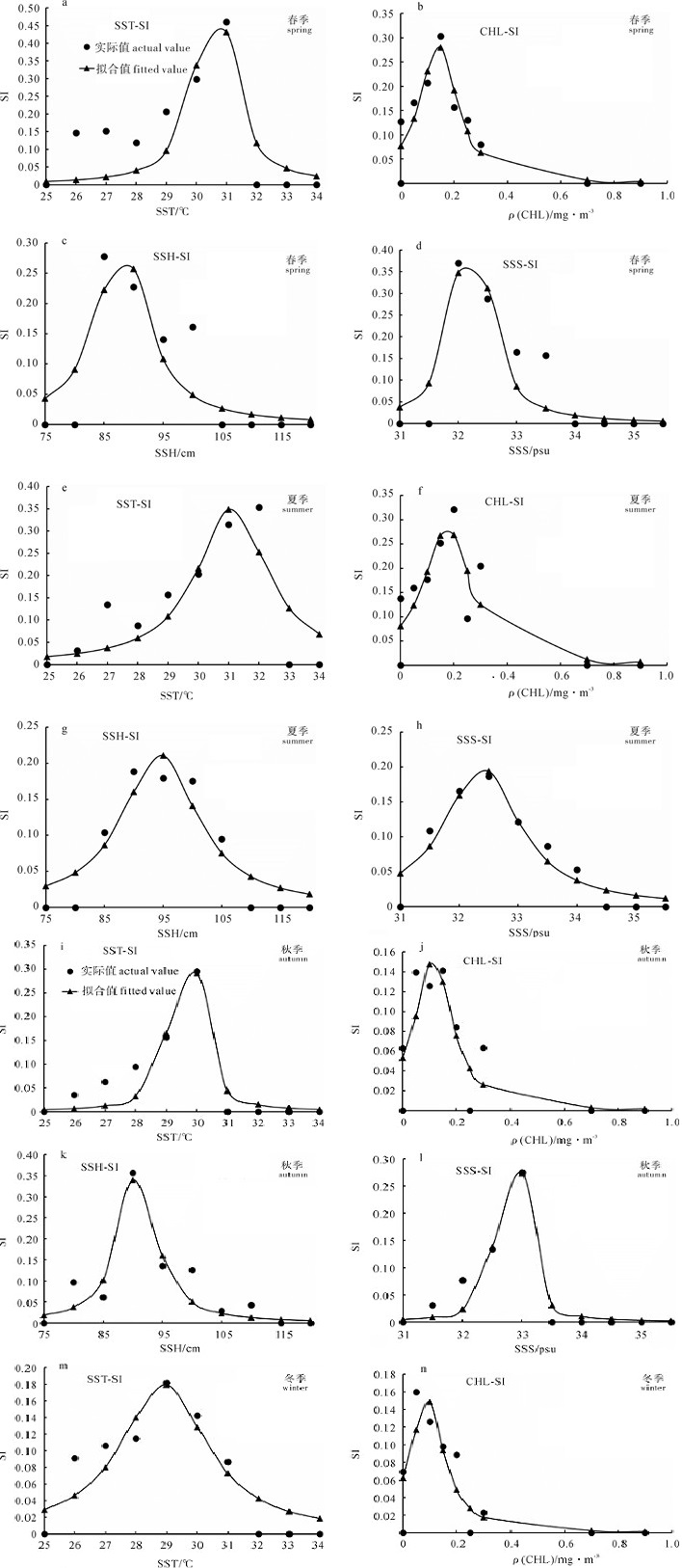
modelP 春季 spring SST-SI SI=1/(3 203.22-209.28×SST+3.42×SST2) 0.000 1 CHL-SI SI=1/(13.07-135.57×CHL+481.36×CHL2) 0.002 1 SSH-SI SI=1/(922.30-20.88×SSH+0.12×SSH2) 0.015 0 SSS-SI SI=1/(17 005.80-1055.14×SSS+16.37×SSS2) 0.000 1 夏季 summer SST-SI SI=1/(1 381.38-88.60×SST+1.42×SST2) 0.000 1 CHL-SI SI=1/(12.41-100.85×CHL+287.03×CHL2) 0.000 1 SSH-SI SI=1/(688.66-14.48×SSH+0.077×SSH2) 0.000 1 SSS-SI SI=1/(8 715.29-537.92×SSS+8.30×SSS2) 0.001 0 秋季 autumn SST-SI SI=1/(9 697.98-654.75×SST+11.05×SST2) 0.000 1 CHL-SI SI=1/(18.82-212.80×CHL+824.48×CHL2) 0.000 2 SSH-SI SI=1/(1 680.16-36.92×SSH+0.20×SSH2) 0.000 1 SSS-SI SI=1/(70 556.52-4 301.55×SSS+65.56×SSS2) 0.001 1 冬季 winter SST-SI SI=1/(1 581.36-108.99×SST+1.88×SST2) 0.000 1 CHL-SI SI=1/(16.18-210.33×CHL+1 158.65×CHL2) 0.000 1 SSH-SI SI=1/(794.84-16.52×SSH+0.086×SSH2) 0.002 1 SSS-SI SI=1/(55 320.72-3 496.99×SSS+55.26×SSS2) 0.015 0 对各因子模型的拟合值与实际值(图 2)进行比对发现,不同季节(春季a~d,夏季e~h,秋季i~l,冬季m~p)不同因子的SI模型基本准确。对各季节各SI模型取导数,则可求出SI最高时的各因子值,结合图 2可知,春季最适SST为30.9 ℃,最适CHL为0.18 mg · m-2,最适SSH为89 cm,最适SSS为32.2 psu;夏季最适SST为30.8 ℃,最适CHL为0.19 mg · m-2,最适SSH为94 cm,最适SSS为32.4 psu;秋季最适SST为29.8 ℃,最适CHL为0.13 mg · m-2,最适SSH为92 cm,最适SSS为32.9 psu;冬季最适SST为29.1 ℃,最适CHL为0.09 mg · m-2,最适SSH为96 cm,最适SSS为31.7 psu。
分别采用最大值法、最小值法、几何平均法和算数平均法建立HSI模型,将剩余的20%渔场数据带入模型,分别验证模型的准确率,理论值与实际值之差小于0.4,即认为模型预报准确,结果如表 2所示。最大值法准确率最低,不到50%;算数平均值法准确率最高,超过75%,模型预报准确。
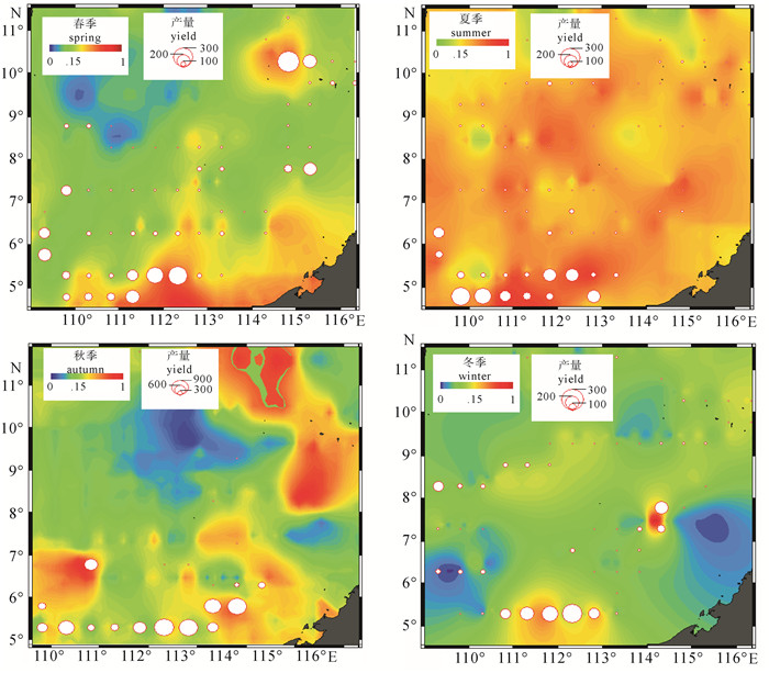
表 2 各模型验证结果Table 2. Model validation results正确 correct 错误 error 正确率/% correct rate 最大值法 max 93 95 49 最小值法 min 103 85 55 几何平均数法 geometric mean 130 58 69 算术平均数法 arithmetic mean 141 47 76 采用算术平均值法,结合Marine Explorer 4.0分不同季节进行作图,发现生物量较高的点均出现在HSI较高的海域,且季节变化明显(图 3),模型预报合理准确。
3. 讨论
该研究采用声学手段评估鸢乌贼生物量,并以此作为渔场好坏的指标,数据比商业生产数据和拖网采样更为可靠,更能反映渔场的真实情况[18-19]。分别采用4种不同方式建立HSI模型,并验证模型的准确性,增加了模型的可信度。利用该研究的HSI模型做渔场分布图,可以看出生物量高的点均出现在HSI高的海域,其余HSI高,但是没有渔场数据的位置是潜在的渔场,可以进行进一步的探捕调查研究印证。
头足类渔场的形成与其生活史、饵料分布、海洋环境等[6-8, 13]密不可分,而海洋环境是影响其生境和饵料生物分布的重要因素,通常认为头足类分布与温度关联性最高[10],通过表温可较为准确地判断其渔场位置,CHL浓度等因子主要通过影响其饵料生物的分布进而影响其渔场分布,具有一定滞后性[7]。该研究中采用的数据均为较易获得的遥感数据,而鸢乌贼的分布恰与SST、CHL、SSS等分布密切相关[11, 13],陈新军等[11]通过遥感数据分析了印度洋鸢乌贼渔场的形成机制,TIAN等[20]分析了阿拉伯海鸢乌贼分布与环境的关系,结果均与此文结果相似;SIRIRAKSOPHON等[21]认为大洋性头足类渔场的形成与温度关系较大,在此研究中可发现,南海鸢乌贼渔场的形成是多种环境因素共同作用的结果,与其他海域的研究既有相同点,又有不同之处,这可能与南海复杂的海底地形和水文环境有关。
目前尚未见到有关南海外海特别是南沙海域渔情预报的相关报道,该研究将陆地和大洋性渔业资源的渔情预报应用到南沙海域,为指导渔业生产、提高生产效率和降低生产成本提供了理论依据。同时,由于该研究仅用一年的数据,存在一定的偶然性,故在今后的研究中要积累长时间序列的数据,结合商业生产数据,建立更加全面综合的渔情预报模型。
-
表 1 各因子SI模型
Table 1 SI model of factors
季节
season变量
variable模型
modelP 春季 spring SST-SI SI=1/(3 203.22-209.28×SST+3.42×SST2) 0.000 1 CHL-SI SI=1/(13.07-135.57×CHL+481.36×CHL2) 0.002 1 SSH-SI SI=1/(922.30-20.88×SSH+0.12×SSH2) 0.015 0 SSS-SI SI=1/(17 005.80-1055.14×SSS+16.37×SSS2) 0.000 1 夏季 summer SST-SI SI=1/(1 381.38-88.60×SST+1.42×SST2) 0.000 1 CHL-SI SI=1/(12.41-100.85×CHL+287.03×CHL2) 0.000 1 SSH-SI SI=1/(688.66-14.48×SSH+0.077×SSH2) 0.000 1 SSS-SI SI=1/(8 715.29-537.92×SSS+8.30×SSS2) 0.001 0 秋季 autumn SST-SI SI=1/(9 697.98-654.75×SST+11.05×SST2) 0.000 1 CHL-SI SI=1/(18.82-212.80×CHL+824.48×CHL2) 0.000 2 SSH-SI SI=1/(1 680.16-36.92×SSH+0.20×SSH2) 0.000 1 SSS-SI SI=1/(70 556.52-4 301.55×SSS+65.56×SSS2) 0.001 1 冬季 winter SST-SI SI=1/(1 581.36-108.99×SST+1.88×SST2) 0.000 1 CHL-SI SI=1/(16.18-210.33×CHL+1 158.65×CHL2) 0.000 1 SSH-SI SI=1/(794.84-16.52×SSH+0.086×SSH2) 0.002 1 SSS-SI SI=1/(55 320.72-3 496.99×SSS+55.26×SSS2) 0.015 0 表 2 各模型验证结果
Table 2 Model validation results
正确 correct 错误 error 正确率/% correct rate 最大值法 max 93 95 49 最小值法 min 103 85 55 几何平均数法 geometric mean 130 58 69 算术平均数法 arithmetic mean 141 47 76 -
[1] 陈新军, 刘必林, 王尧耕. 世界头足类[M]. 北京: 海洋出版社, 2009: 398-342. https://xueshu.baidu.com/usercenter/paper/show?paperid=34d7808bc84eacd6711d8f6d157b997a&site=xueshu_se [2] 邹建伟, 陈立峰, 林蒋进, 等. 南海外海灯光罩网主要渔场分布及变动研究——基于广西渔船的生产监测统计[J]. 南方水产科学, 2014, 10(4): 78-84. doi: 10.3969/j.issn.2095-0780.2014.04.013 [3] 张鹏, 杨吝, 张旭丰, 等. 南海金枪鱼和鸢乌贼资源开发现状及前景[J]. 南方水产, 2010, 6(1): 68-74. doi: 10.3969/j.issn.1673-2227.2010.01.012 [4] 陈新军, 冯波, 许柳雄. 印度洋大眼金枪鱼栖息地指数研究及其比较[J]. 中国水产科学, 2008, 15(2): 269-278. doi: 10.3321/j.issn:1005-8737.2008.02.011 [5] OLDEN J D, JACKSON D A. Fish-habitat relationships in lakes: gaining predictive and explanatory insight by using artificial neural networks[J]. Trans Am Fish Soc, 2001, 130(5): 878-897. doi: 10.1577/1548-8659(2001)130<0878:FHRILG>2.0.CO;2
[6] THOMAS R G. Fish habitat and coastal restoration in Louisiana[C]. Bethesda, Maryland: American Fisheries Society Symposium, 1999: 240-251. https://xueshu.baidu.com/usercenter/paper/show?paperid=ed324d2db052fb94c44ed7d7d3b6398b&site=xueshu_se&hitarticle=1
[7] CHEN X J, LIU B L, TIAN S Q, et al. Fishery biology of purpleback squid, Sthenoteuthis oualaniensis, in the northwest Indian Ocean[J]. Fish Res, 2007, 83(1): 98-104. doi: 10.1016/j.fishres.2006.09.005
[8] 颜云榕, 冯波, 卢伙胜, 等. 南沙群岛北部海域鸢乌贼(Sthenoteuthis oualaniensis) 夏季渔业生物学研究[J]. 海洋与湖沼, 2012, 43(6): 1177-1187. doi: 10.11693/hyhz201206021021 [9] 刘必林, 陈新军, 钟俊生. 采用耳石研究印度洋西北海域鸢乌贼的年龄, 生长和种群结构[J]. 大连水产学院学报, 2009, 24(3): 206-212. doi: 10.3969/j.issn.1000-9957.2009.03.004 [10] 陈新军, 刘必林, 田思泉等. 利用基于表温因子的栖息地模型预测西北太平洋柔鱼(Ommastrephes bartramii) 渔场[J]. 海洋与湖沼, 2009, 24 (6): 707-713. doi: 10.3321/j.issn:0029-814X.2009.06.006 [11] 陈新军, 叶旭昌. 印度洋西北部海域鸢乌贼渔场与海洋环境因子关系的初步分析[J]. 上海水产大学学报, 2005, 14(1): 55-60. doi: 10.3969/j.issn.1004-7271.2005.01.011 [12] 邵锋, 陈新军. 印度洋西北海域鸢乌贼渔场分布与海面高度的关系[J]. 海洋科学, 2008, 32(11): 88-92. http://qdhys.ijournal.cn/hykx/ch/reader/view_abstract.aspx?file_no=20081118&flag=1 [13] 杨晓明, 陈新军, 周应祺等. 基于海洋遥感的西北印度洋鸢乌贼渔场形成机制的初步分析[J]. 水产学报, 2006, 30(5): 669-675. doi: 10.3724/SP.J.1231 [14] 张俊, 陈作志, 陈国宝, 等. 南海鸢乌贼水声学测量和评估相关技术研究[J]. 南方水产科学, 2014, 10(6): 1-11. doi: 10.3969/j.issn.2095-0780.2014.06.001 [15] 任若恩, 王惠文. 多元统计数据分析: 理论, 方法, 实例[M]. 北京: 国防工业出版社, 1997: 89-97. https://xueshu.baidu.com/usercenter/paper/show?paperid=037b5a40df1e61fc16f7bd601309bce6&site=xueshu_se&hitarticle=1 [16] 汪荣鑫. 数理统计[M]. 西安: 西安交通大学出版社, 1986: 36-54. [17] 高峰, 陈新军, 范江涛, 等. 西南大西洋阿根廷滑柔鱼中心渔场预报的实现及验证[J]. 上海海洋大学学报, 2011, 20(5): 754-758. https://www.shhydxxb.com/shhy/article/abstract/201101115?st=search [18] STARR R, THOME R. Acoustic assessment of squid stocks[J]. FAO Fisheries Technical Paper, 1998: 181-198. https://xueshu.baidu.com/usercenter/paper/show?paperid=bd49b5235760a1d57c8c8677aa45e9ce&site=xueshu_se&hitarticle=1
[19] ZHANG J, CHEN Z Z, CHEN G B, et al. Hydroacoustic studies on the commercially important squid Sthenoteuthis oualaniensis in the South China Sea[J]. Fish Res, 2015, 169: 45-51. doi: 10.1016/j.fi
[20] TIAN S Q, CHEN X J, YANG X. Study on the fishing ground distribution of Symlectoteuthis oualaniensis and its relationship with the environmental factors in the high sea of the Northern Arabian Sea[J]. Trans Oceanol Limnol, 2006, 1: 51-57. https://www.semanticscholar.org/paper/STUDY-ON-THE-FISHING-GROUND-DISTRIBUTION-OF-AND-ITS-Xinjun/560624c608a3da7fea608d07461d40a270935169
[21] SIRIRAKSOPHON S, NAKAMURA Y, PRADIT S, et al. Ecological aspects of oceanic squid, Sthenoteuthis oualaniensis (Lesson) in the South China Sea, Area III: Western Philippines: proceedings of the SEAFDEC Seminar on Fishery Resources in the South China Sea, Area III: Western Philippines, Manila, July 13-15, 1999[C]. Bangkok, Thailand: SEAFDEC, 2000: 3. http://repository.seafdec.org/handle/20.500.12066/4347
-
期刊类型引用(4)
1. 吴胜,任兰英,高旭,刘岩,宫庆礼. 柴油水溶性组分对鼠尾藻和孔石莼生长及抗氧化酶的影响. 中国海洋大学学报(自然科学版). 2023(07): 31-41 .  百度学术
百度学术
2. 龚芳芳,李勇勇,王晔,陈淑敏,张玉琦,刘英丹,孟天宇,娄永江. 龙须菜中硼的化学形态分析. 宁波大学学报(理工版). 2021(01): 15-20 .  百度学术
百度学术
3. 于娇,胡晓,杨贤庆,陈胜军. 海洋藻类藻胆蛋白的提取、纯化与应用研究进展. 食品工业科技. 2018(11): 314-318+326 .  百度学术
百度学术
4. 王云祥,李正,秦传新,陈丕茂,袁华荣,周文礼. 不同季节江蓠脱落物对大型海藻场上覆水的影响. 南方水产科学. 2016(02): 13-20 .  本站查看
本站查看
其他类型引用(3)


 下载:
下载:


 粤公网安备 44010502001741号
